•

![]()
![]()
![]()
![]()
![]()
![]()
![]()
![]()
![]()
![]()
![]()
![]()
![]()
![]()
![]()
![]()
![]()
![]()
![]()
![]()
![]()
![]()
![]()
![]()
![]()
![]()
![]()
![]()
![]()
![]()
![]()
![]()
![]()
![]()
![]()
![]()
![]()
![]()
![]()
![]()
![]()
![]()
![]()
![]()
![]()
![]()
![]()
![]()
![]()
![]()
![]()
![]()
|
•
|
|
|
Return of Arabia to being full of pastures & Rivers
Prophet Mohammad made a very significant prophecy. He prophesied in a Hadith (transmitted in 2 variations) that the land of the Arabs (Arabian Peninsula) will return to being paradises and rivers. Through our analysis of numerical values of words in this prophecy, we have managed to discover in which this is likely to happen. عن أبي هريرة رضي الله عنه أن النبي صلى الله عليه و سلم قال : " لا تقوم الساعةُ حتى يكثر المال ويفيض ، حتى يخرج الرجل بزكاة ماله فلا يجد أحداً يقبلها منه ، و حتى تعود أرض العرب مروجاً و أنهاراً " . صحيح مسلم Based on Abu Huraira, Prophet Mohammad صلى الله عليه وسلم said: " The Hour (of Resurrection) will not occur..... until the land of the Arabs returns to being pastures and rivers." (Sahih Muslim).
A variation of this Hadith appears in Musnad Ahmad: لن تقوم الساعه حتى تعود جزيرة العرب كما كانت جنات وأنهار The Hour (of Resurrection) will not occur until the Arabian Peninsula returns, as it used to be, paradises and rivers." (Musnad Ahmad)
The Quran in verses 131-135 of Sura Al-Shu'ara (Chapter 26) mentions that the land of people of Aad in Arabia used to be like paradise before God destroyed the city and turned Arabia into desert because they disobeyed God. There are lots of indications that the U.S. is similar to Aad and will receive a similar punishment from God: أرض العرب كانت أرضاً خصبة ، و هي حقيقة أكدها القرآن الكريم فيما ذكره تعالى من قول نبي الله هود عليه السلام و هو يدعو قومه عاد الذين كانوا يسكنون في الجنوب من أرض العرب ، قال تعالى : { فَاتَّقُوا اللهَ وَ أَطِيعُونِ ( 131 ) و اتَّقُوا الذَّي أَمَدَّكُم بِمَا تَعلَمُونَ ( 132 ) أَمَدَّكُم بِأَنعَامٍ وَبَنيِن ( 133 ) وَجَنَّاتٍ وَ عُيُونٍ ( 134 ) إنّي أَخَافُ عَلَيكُم عَذَابَ يَومٍ عَظِيمٍ } [ الشعراء : 131 - 135 ] 131. So fear Allah and obey me. 132. And fear Him (Allah) Who has helped you with the things which you know. 133. He has helped you with cattle and children, 134. And (also) with gardens and springs. 135. Surely I fear the torment of a Terrible Day coming upon you. (Chapter 26: 131-135)
At the time of Prophet Mohammad and until today, Arabia has been a desert. This indicates that the Arabian Peninsula used to be green pastures many centuries ago, instead of its current condition as a desert. More importantly, this means we should expect a major cosmic event in the upcoming years that will cause such a dramatic change in World climate.
This prophecy has started to materialize: A Muslim man named Zaheer has recently reported on his blog ( http://zaheersblog.blogspot.com ) that he went to Saudi Arabia to perform Umrah. He went to Madina first and then Makka. On June 27, 2010, on his way to Makka, may be about twenty five miles from it, he started noticing greenery. The whole desert looked like a faint green meadow. This greenery was not the result of some intentional gardening or landscaping. This is what used to be a bare desert and it is miles and miles of land. Another Muslim, Faraz Omar, reported, in his March 16, 2010 article, noticing after visiting Mecca that Saudi Arabia is becoming green. A long stretch of the highway, for God knows how many kilometers, has unmistakably become quite green with desert grass:. The following are photos taken by Faraz Omar showing the new greenery in Saudi Arabia:
Furthermore, the following video below talks about a major crack in the earth in Ethiopia that has formed in 2005, due to an earthquake, which may lead Africa to split into two continents separated by an ocean. This will make the Arabian Peninsula on the ocean. This will make the climate in Arabia milder, turning Arabia into green pastures as Prophet Mohammad has prophesied.
Kuwait & Wadi Al-Batin valley River Dr. Farouq El-Baz, NASA scientist and Professor at Boston University piqued the interest of Biblical scholars around the world with his announcement of the so-called Kuwait River. The idea that a river once flowed across the deserts of Arabia, and somehow connected with the Tigris and/or Euphrates River, seemed far-fetched. Yet evidence for such a river came from the satellite radar images taken during the 1994 mission of the Space Shuttle Endeavor. Al-Baz studied the images, and noticed that traces of a defunct river that crossed northern Arabia from west to east were visible beneath the sands, thanks to the ground-penetrating capabilities of the radar technologies. He called it the Kuwait River (believed to have ran through Wadi Al-Batin valley in Northeastern Saudi Arabia, in ancient times) for that is where it apparently connected with the Euphrates or emptied into the Persian Gulf. New Scientist magazine in April 3, 1993 reported the following article: "Geologists studying remote sensing images of Arabia have found a dry riverbed covered by desert sands. The 850-kilometre channel begins in the Hijaz Mountains of western Saudi Arabia and ends in a delta that covers more than two-thirds of Kuwait, says Farouk El-Baz, director of the centre for remote sensing at Boston University. Parts of the ancient channel had been mapped as 'wadis', but no one had recognised it as a large river system because large dune fields cut across it. Arabia has had wet periods at times over the past 200 000 years. Water last flowed in what El-Baz calls the 'Kuwait River' between 5000 and 11 000 years ago; some stretches of the river may have been up to 5 kilometres wide. Then as the region became one of the driest in the world, blowing sands covered the channel. The river runs along a fault, so that there should still be ground water deep in the channel. El-Baz says this water might be tapped by wells several hundred metres deep. Sand-covered parts of the old channel may contain the remains of prehistoric settlements, from the time before the river dried. El-Baz sees signs to the south of three other dry rivers that would have drained other parts of Arabia."
Fig. 1 Map Showing Eden’s
Long-lost River Four rivers are mentioned in the
narrative of the ordering of creation in Genesis 2, but as any commentary will
tell you, only three are known. The commentaries, it turns out, will have to be
rewritten. The imagery also overturned the
prevailing assumption of climactic stability since the end of the last ice age
(ending c. 9000BC) held by a majority of ancient Near Eastern scholars until
recently. It would appear, as James Sauer puts it, that Genesis contains some
very ancient historical memory about ancient Near Eastern geography. How
ancient? The presence of this river far predates the geography described by the
Sumerians and the Egyptians, which are the earliest civilizations known to
historians, yet its existence and location are just as they are found in the
Bible. “This quartz-sulfide-gold vein at Mahd edh-Dhahab is still mined today. The mine, which some identify as King Solomon’s mine (1 Kings 9:26–28), produces more than 5 tons of gold a year” (Sauer, op cit).
The Earliest Civilization and the Bible Disclaimer: This article is authored by a non-Muslim. We do not endorse this article, but it is informative and worth reading.
The Edenic Pishon River (Pison River) is Wadi Bishah (Bishain) and Wadi Baish (Baysh) and Havilah (Hebrew: Hawila; Targum: Chavila) is the Khaulan/Khawlan/Haulan/Hawlan Yemeni Tribes by Walter Reinhold Warttig Mattfeld y de la Torre, M.A. Ed. Source: http://www.bibleorigins.net/pishonrivermapwadibishahasir.html
Disclaimer: This article
is authored by a non-Muslim. We do not endorse this article, but it is
informative and worth reading.
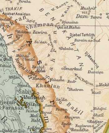
Below two locations within the Yemen bear the geographical designation Khawlan (Khaulan, Haulan). A Khawlan just east of the capital of Yemen, San'a, and the other Khawlan lying further south near Radman and Himyar, said area(s) being proposed by some scholars to be Havilah (the Targum's Chavilah) of the Bible. Strangely, no Khawlan lies between San'a and Mecca as stated above by Hastings in 1898. However Muller (cf. below) cites Halevy about gold being found at Sirwah in stream beds in the Khawlan and Sirwah does appear on the below map between Saba and Khawlan, so apparently Muller favors the "gold of Havilah" to be the Khawlan east of San'a (for the below map cf. p. 37. Map 3. "South Arabia" Robert G. Hoyland. Arabia and the Arabs, From the Bronze Age to the coming of Islam. London & New York. Routledge. 2001). Special note: Muller states that there is a THIRD tribal federation in the Yemen called the "Northern" Haulan near Sa`dah. Unfortunately the below map does not show the city of Sa`dah and this tribal federation. Sa`dah lies south of Najran and north of Nashq on the below map. Sayce (1898) noted a Khaulan in Tihamah between Mecca and San'a (cf. above). I have established that this Khaulan is today in Saudi Arabia in the province of Asir. It appears in a Google Saudi Arabian Gazeeter as a "Tribal Region" located to the south of the city of Abha, east of the port of Jizan on the Red Sea and west of the village of Aba Saud. The Saudi "Khaulan Tribal Area" is very near the northern border of the Yemen in the Asir mountains which border the seacoast plain called Tihamah.
Please click here to see the
location of the Saudi Khaulan (Sayce's Tihamah Khaulan). All this is to say that Hoyland's below map shows only TWO of the FOUR tribal federations known as the
Haulan, Khaulan, Khawlan Tribal Areas. Note: Wadi Baish and Wadi Bishah are both
in Saudi Arabia not the Yemen.
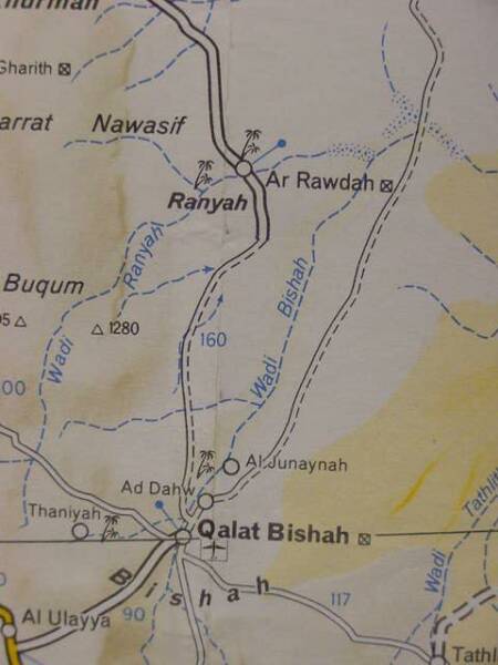
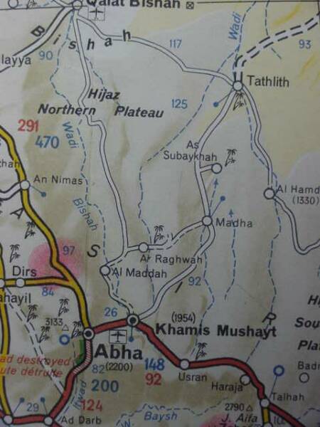
Wadi Bishah is some 300 miles in length and it begins in the coastal mountains of Asir, the headwaters beginning near Khamis Mushayt east of Abha and draining northwards to Qal'at Bishah (cf. the below map for these two locations), emptying into the desert sands of the Nafud Ad Dahy to the ENE of Qal'at Bishah. Sayce's Tihamah Khaulan in Asir lies south of Abha near which are the headwaters of Wadi Bishah. If Bishah is the Pishon River, then the FOUR Khaualan Tribal Areas all lie to the south of the Bishah. In other words to get to the Khaulans, Wadi Bishah must first be crossed, perhaps this is why the Pishon encircles the land of Havilah in Genesis? The Bible takes note of another great river that
served as a border to a region (Judah), the "river of Egypt" a wadi like Bishah,
today called Wadi el Arish in the midst of the Sinai peninsula. The Septuaginta
Bible written in Greek at Alexandria, Egypt in the 3rd century BC by Jews for
Jews identified the Nile with the Gihon that flows through Cush (Ethiopia of the
Septuaginta). Like the Bishah, the Nile drains "northward" too.
Below, Wadi Bishah, divided into three maps for clarity. (cf. Map titled Africa, North East Arabia. Michelin. No. 954. Paris, France. Scale: 1:4,000,000. 1990)
Below, another map showing Wadi Bishah as Wadi Bishain. If Bishain is not an "error," and if it is a legitimate alternate rendering of Bishah, could the "n" preserve the Pishon? (cf. Map titled Near & Middle East. Hammond World Atlas. Scale: 1:4,000,000. Langenscheidt Publishing Group. Munich, Germany. 2006)
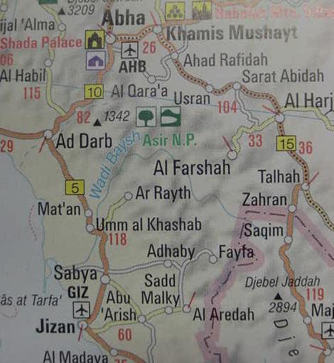
Below, Wadi Baysh (Wady Baish on earlier maps), a possible contender for the Pishon river according to Muller. Wadi Bishah is the blue dotted line above Khamis Mushayt going by Al Maddah (cf. map titled Africa, North East. Map number 954. Paris, France. Michelin. Map scale: 1:4,000,000. 1 centimeter: 40 kilometers. 1990). This map suggests Wadi Baysh/Baish is about 60 miles or 100 kilometers in length. Sayce's Tihamah Khaulan between San'a and Mecca is apparently today in the Asir province of Saudi Arabia just south of Abha which appears on the below map. That is to say Wadi Baysh/Baish flows through this Khawlan, hence the reason Muller suggests it might be the Pishon associated with the land of Havilah. The border between Saudi Arabia and Yemen is the line of crosses (+++++++) on the below map.
Below, another cartographical rendering of Wadi Baysh/Baish, the Pishon? (cf. map titled Near & Middle East. Hammond International. Scale: 1:4,000,000. Langenscheidt Publishing Group. Munchen [Munich], Deutschland. 2006). The map to the viewer's right reveals that Wadi Baysh (Wadi Baish on maps before 1970) is in the midst of the Khaulan (Havilah) area, draining it and providing it water, it is a very remarkable river in that it has water year-round, a rare sight in this part of the world (compare the location of Sabya on the left map with Sabiya on the right map). Also note Havilah is the "son of Joktan" in Genesis 10:26-29 and how close Khaulan is to the Beni Kahtan "Sons of Joktan" tribal federation on the below map (1929, Milan, Italy).
HAVILAH (PERSON) [Hebrew hawila]
Since in Old South Arabic dhb does
not only mean gold but also a type of incense, it is possible that zahab tob in
Gen 2:12 does not refer to “good gold” but rather to a fragrant resin (cf. de
Langhe 1959: 493).In Gen 25:18 hawila, which by the Israelites might have been
connected with Hebrew hol, “sand,” designates presumably the SE desert border of
the region where the Ishmaelites settled. From this fact and from the reference
to the Chaulotaîoi by Eratosthenes (Strabo, Geog. 16.4.2), H. von Wissmann
(1970: 905–80, esp. 947–54) concluded that there must have existed a colonial
Sabean Haulan in NW Arabia along the incense road before or perhaps still during
the Minaean period in the oasis of Dedan. Probably this N Arabian hawila is to
be distinguished from the S Arabian Haulan and perhaps to be compared with the
tribe of hwlt, which is repeatedly mentioned in the Safaitic inscriptions and
which might be identified with the Avalitae of Pliny (HN 6.157) and the later
Arabian tribe of Hawala. Possibly the old biblical name of this region survives
in the name of the N Arabian town of Ha`il (cf. Knauf 1985: 64). The borders of
the Ishmaelites in Gen 25:18 with the local destination hawila have also been
taken over in 1 Sam 15:7 and transferred to the Amalekites. W. W. Muller.
Could Ophir, identified with the fine gold of Ophir in the Bible be recalled in the tribal group called al-'Ifar, in Dhofar (Zhufar on some maps), west of Wadi Hadrhramaut (some scolars identifying Joktan's son Hazarmaveth with Hadhramawt)?
Could the tribal lands of Joktan and his sons said to extend from Mesha to
Sephar and the hill country of the east be alluding to present-day Khamis
Mushayt, in the mountains of Asir (Saudi Arabia) lying just south of Qahtan (and
north of Najran) and could Sephar and its eastern hill country be modern-day
Dhofar and its hill country (famed for its frankincense trees), alternately
rendered on some maps as Zufar or Zofar? This region is a land of precious
stones, incense and gold, items associated with Joktan's patrimony (Sheba,
Havilah, Ophir). The main caravan route appears to have left the Yemen heading
north to Najran and Khamis Mushayt. That is to say "if" Mesha is Mushayt, it was
a major stop on the caravan route to Israel from the Yemen? Below is Yemen's Gold Map:
A report assessing potential gold lodes in the Yemen made in 2007 has
identified some 12 locations, cf. "Investment Opportunities in the Metallic
Minerals Sector in Yemen. Evaluation and Promotion." Republic of Yemen. Ministry
of Oil and Minerals. Geological Survey and Minerals Resources Board. 2007(Please
click here for the report).
A Google search turned up a listing of semi-precious stones found in the
Yemen: carnelian, sky agate, honey agate, opal, gasber, flourite and onyx. Note
that Sauer (below) understood onyx was associated with Havliah. Onyx is found in
the Yemen. Perhaps these represent the precious stones associated with the lands
of Havilah and Sheba?
Please click here for a "Rough Tribal Map of Arabia." 1949. H. R. P. Dickson.
The Arab of the Desert. London.
Sauer, in error thought that Mahd adh-Dhahab was the "only area" possessing
gold in antiquity. As revealed by geological surveys conducted in the Yemen
(cf. above Mallory-Greenough, 2000) gold mines also existed in antiquity in
the Yemen. Sauer consequently proposed in 1996 that Havilah, famous for its
gold, was most probably the vicinity of Mahd adh-Dhahab and Medina in western
Saudi Arabia. In 1996, when Sauer wrote his article the Iron Age, Gold Mines at
al Maraziq in the al Jawf region of the Yemen had not yet been identified,
that event would occur in 2000, one year after Sauer's death in 1999.
Because in 1996 Mahd adh-Dhahab was the only "verified" ancient gold mine in
Arabia known to scholars, he understandably associated it with Havilah's gold.
The below quotes are from James A. Sauer, "A Lost River of Eden, Rediscovering
the Pishon." pp. 3-11, in Molly Dewsnap Meinhardt, editor, Mysteries of the
Bible, From the Garden of Eden to the Shroud of Turin. Washington, D.C.
Biblical Archaeological Society. 2004. This is apparently a reprint, with a
different title, of James A. Sauer, "The River Runs Dry: Creation Story
Preserves Historical Memory." The Biblical Archaeology Review, Vol. 22,
No. 4, July/August 1996, pp. 52-54, 57, 64. The late James A. Sauer was a
Curator and Research Associate at Harvard's Semitic Museum and considered an
authority on the archaeology of Jordan he died in 1999.
Sauer on Mahd adh-Dhahab being the only known_site for Arabian gold, which
he uses "to fix" the location of the land of Havilah and its Pishon River:
"An important key is the Biblical phrase "the gold of that land is good." Only
one place in Arabia has such a deposit -the famous site of Mahd edh-Dhahab,
the "Cradle of Gold." This ancient and modern gold mine is located about 125
miles south of Medina, near the headwaters of the Kuwait River."
(p. 8. James Sauer."A Lost River of Eden, Rediscovering the Pishon.")
To his credit, Sauer did acknowledge a "problem" with his Havilah proposal,
that bdellium also associated with Havilah (a resin), appears to be unknown as
a physical resource near Mahd adh-Dhahab or Medina, it is a resource however
of the Yemen. To get around this "problem", he proposed that the Yemen's
bdellium was "traded" in the Medina area and thus came to associated as a
physical resource of Havilah:
"The Biblical text also mentions bdellium and onyx. Aromatic resins such as
bdellium are known in Yemen to the southwest, and, although they are not
thought to have been produced in the vicinity of Medina, they could easily
have been brought there."
(p. 8. James Sauer. "A Lost River of Eden, Rediscovering the Pishon.")
Another "problem" acknowledged by Sauer was Havilah's precious stones. Again
he acknowledged that the area of Southwest Arabia ( the modern Yemen) is famed
for a variety of semi-precious stones rather than the Medina area:
"Semiprecious stones such as alabaster also come from these areas, but it is
uncertain whether other precious stones, such as onyx, do. In any event, no
other river would seem to fit the Biblical description. I am inclined
therefore to think that the Kuwait River could well be the Pishon of the
Bible."
(p. 8. James Sauer. "A Lost River of Eden, Rediscovering the Pishon.")
The problem? Havilah appears for most scholars to be associated with the
Khaulan (Khawlan) in the Yemen, which also has evidence of gold mines being
worked in the Iron Age. Wadi Bishah (the Pishon?) must be crossed before
reaching Yemen's Sheba and Haulan/Khawlan (Havilah?), perhaps this is why the
Pishon is said to encircle Havilah, you must cross the Bishah before entering
the gold-bearing region of the Yemen (ancient gold mines have been found to
the southeast of Sa`dah in the al Maraziq area of the al Jawf region).
I understand Sauer is wrong about Mahd adh-Dhahab and Medina being the
region of Havilah and Kuwait River (Wadi al-Batin) being the Pishon River for
the following reasons:
(1) Havilah appears for some scholars to be associated with the Khawlan tribal
federation in the Yemen, no such regional name or federation exists near
Medina or Mahd adh-Dhahab. Muller (cf. above) identified THREE tribal
federations within the Yemen all bearing the name Khawlan or Haulan: (1.) A
"northern" Haulan tribal federation near Sa`dah; (2.) An "Eastern or Southern
Haulan tribal federation" near Sirwah; (3.) A Haulan tribal federation near
Radman, south of Sana'a. Sayce (1898) identified a "fourth" Khaulan tribal
area with the Tihamah coastline bordering the Red Sea. Today this area lies in
Saudi Arabia in the province of Asir, to the south of Abha, very near the
northwestern border of the modern Yemen. Pritchard's map (cf. above) shows
Havilah as near the Red Sea and probably this is based on Sayce's Tihamah
Khaulan in Saudi Arabia.
(2) Sauer was simply wrong in his belief that the "only known source" for
Arabian gold was Mahd adh-Dhahab. Geological surveys in the Yemen have
identified gold mines in this area in the al Maraziq area within the al Jawf
region, east of Sa`dah dating from Iron Age times and Solomon and the Queen
of Sheba were Iron Age monarchs (cf. Leanne Mallory-Greenough et al. "Iron Age
Gold Mining: A Preliminary Report on Camps in the Al Maraziq Region, Yemen."
Arabian Archaeology and Epigraphy. Vol. 11. No. 2. Nov. 2000. pp.
223-236). Note: According to Muller the "northern" tribal federation of Haulan
is located in the Sa`dah area, and just southeast of Sa`dah are Iron Age gold
mining camps of the al Jawf region (Wadi al Jawf?). Were these mines
identified in Genesis with the "northern" Haulan tribal federation near Sa`dah?
A Jew traveling south from Jerusalem, would most like have crossed Wadi Bishah
(Genesis' Pishon River?) before reaching the land of Hawila/Havilah and the
area of the "northern" Haulan tribal federation at Sa`dah which may have
controlled the Iron Age mining camps southeast of that location at al Jawf.
Mallory-Greenough speculated about the nearness of the al Jawf Iron Age gold
mines to the frankincense trade route extending from the land of Sheba and
Jerusalem in King Solomon's days (cf. above).
(3) In antiquity, the Yemen (Southwest Arabia) was famed for resins, most
particularly frankincense of the Dhofar/Zufar region (biblical Sephar? Ge
10:30) east of Wady Hadramawt (biblical Hazarmaveth, a brother of Sheba and
Havilah, cf. Ge 10:26-30).
(4) Havilah is a "brother" of Sheba and Hazarmaveth (Ge 10:26-29) and these
names appear in the Yemen under Khawlan/Haulan, Saba and Hadramawt.
(5) Ophir was a "brother" of Sheba, Havilah and Hazarmaveth too. The Bible
speaks of the gold of Ophir. Is it possible that the gold adits of the Jauf
area came to be "morphed" into the gold of Oph[-ir] by the Hebrews? That is to
say Jauf "became" Oph[ir]?
(6) Apparently unknown (?) to Sauer, the Jewish scholar Halévy reported that
as an eyewitness in 1870 in Sirwah in Haulan (in the Yemen), he saw Arabs
washing gold and noted that gold was found in small grains in the sand and in
the river bed.
(7) Sauer understood onyx (biblical shoham stone) was a precious stone
associated with Havilah and it is attested as being local to the Yemen.
(8) The Queen of Sheba brought Solomon much gold, precious stones and resins
(incense) and she is called in the New Testament "the queen of the south."
Yemen (Yamin) means "south" in the sense that as one faces east one's right
hand is to the "South." So the Queen of the South" (Yemen) came from a land of
gold, precious stones and resins, which align somewhat with Havilah, the
brother of Sheba and Hazarmaveth (Hadramawt of the Yemen).
There is a "problem" that will not go away for any scholarly proposal for
Havilah and its Pishon river: No river subdivides into the Euphrates, Hidekkel
(Tigris) and Pishon (Bishah?) as portrayed in Genesis, but then Sauer's
"Kuwait River" (Wadi al Batin) doesn't align either with Genesis' notion of
one river subdividing into four after leaving the garden in Eden. Sauer is not
"alone" in proposing that four streams converged_ at the Garden of Eden
rather than the more common understanding that a river subdivided into four
streams. Earlier scholars like the late Ephraim A. Spieser in an article dated
1959 had proposed four streams converged at Eden's garden which he located
in the Lower Mesopotamiam marshlands near Qurnah (Kurnah) where the Euphrates
and Tigris rivers converge today. Local native traditions claim Qurnah is
the site of the Garden of Eden. Of interest here is that the 1st century A.D.
Jewish scholar Flavius Josephus understood that the river of Eden subdivided
into four streams that encompassed the world (he associated the Gihon with the
Nile).
An Englishman, H. St. John Philby, described (1936) the area about Wadi Baish/Baysh
as being "like the Bible's Garden of Eden," he was mapping this area on behalf
of the Saudi Arabian government (I am in agreement with Muller that Havilah is
the Khaulan and that its Pishon River is a conflation of Wadi Baish and Wadi
Bishah both of which drain near each other from the Asir mountains):
"As he trekked down to the coastal plain at Jaizan, which he made his
headquarters for his three final assaults on the foothill frontier, he came
across scenes and human types never met with in the rest of his Arabian
experience:
"The garden of Eden must be very like this valley [he wrote to Dora from the
Wadi Baish] and the human beings one meets from time to time might have
stepped straight out of Genesis, naked except for a loin-cloth and sometimes a
rifle, and with very fuzzy greased hair. All prefer walking to riding... and
drink from the brook whenever they are thirsty. When tending goats on the
hillside they sit so still... that one doesn't notice them unless they move or
speak."
(Elizabeth Monroe. "Into the Highlands." ARAMCO World Magazine. 1974.
Vol. 1)
Please click here and scroll down to pp. 433-450 for Philby's in-depth
delightful description of Wadi Baish (including its headwaters and
tributaries) and the Khawlan (Havilah) as preserved in his explorer's journal
dated 5-31 December 1936. After reading his account you will understand "why"
Havilah (the Khawlan tribal region) and its Pishon River (Wadi Baish/Baysh)
was associated with Paradise on earth by the Jews by circa 562-560 BC! Philby
describes a wonderous world of copious amounts of water gushing over rapids,
gaily bubbling over pebbles, flanked by towering Daum Palm Trees with nuts and
wild fig trees for monkeys to eat of, flocks of aquatic birds, powerful
aromatic scents in the air from plants near the river (drawing butterflies),
towering reeds and marsh grasses, nomadic herdsmen of cattle, sheep and goats,
enumerating the sub-clans of the Qhatan (biblical Joktan) and the Khaulan
(biblical Havilah).
Please click here for the PDF version. Philby provides interesting
commentary on the various tribes (bani) and sub-clans of this area,
some of whom "might" appear as Joktan's sons in Genesis 10's Table of Nations.
Someone could "mine" his account for such genealogical data!
Philby on the Qahtan and Khaulan tribal confederations associated with Wadi
Baish (Biblical: Joktan, Havilah, and the Pishon River):
"The head of Wadi Baish at the junction of Raha and Dafa'...The Ahl al Raith
are a section of Khaulan, and their territory is separated from Ahl Sari' (Qahtan)
by Wadi Dafa', and from Jaub (also Qahtan) by Wadi Baish...The Bani Malik
tribe, a branch of Khaulan..."
(pp. 445, 446, 502. H. Sr. J. B. Philby. Arabian Highlands. Ithaca, New
York. Cornell University Press. Published for
The Middle East Institute of Washington D.C. 1952. 771 pages with an
exhaustive index and three maps)
Below, a map showing Wadi Baysh's (Wadi Baish's) origins as two headwaters,
the northern headwater draining from the south slopes of the Asir mountain
range south of Abha. Philby (1936, 1952) lists over a dozen streams as
tributaries of the Baish as it descends from the heights of the Asir
mountains.
Below, a larger map of Wadi Baysh/Baish (apparently printed in Japanese?)
showing the stream reaching the Red Sea just north of the port of Jizan, the
Baish's (Baysh's) "numerous tributaries" are not shown on any of the maps
accompanying this article because I was unable to find such maps on the
internet. The Yemen, not on the below map, is south of the dotted line border
of Saudi Arabia.
Philby (1936) on Wadi Baish tributaries:
"For the first two hours...of our march...the steep slope of the Baid massif
formed the right bank of the Baish...hemmed in...by...the Jabel Raith...whose
ravines head no fewer than eighteen tributaries of Baish down to our...camp at
Mishaqa...bordering the Tihama plain."
(p. 450. H. Sr. J. B. Philby. Arabian Highlands. Ithaca, New York.
Cornell University Press. Published for
The Middle East Institute of Washington D.C. 1952)
Havilah according to Strong's Hebrew and Chaldee Dictionary is wrongly
pronounced in English as "Havilah" its correct pronunciation in Hebrew
apparently is Chavilah or Khav-ee-law':
"Strong # 2341, Chaviylah, khav-ee-law', probably
from # 2342 Chuwl, khool or Chiyl, kheel, a
primitive root, to twist or whirl in a spiral manner." (James Strong.
Strong's Exhaustive Concordance, Complete and Unabridged. Waco, Texas.
Word Books. 1977)
Muller on Havilah:
"Havilah, Hebrew: hawila. The rich land surrounded by the river
Pishon..."
(p. 82. vol. 3. W. W. Muller. "Havilah." David Noel Freedman. Editor. The
Anchor Bible Dictionary. New York. Doubleday. 1992)
Below, a map (1862) showing Havilah as the Chaulan region being watered by
Wadi Baish (the Pishon river of Garden of Eden fame?) in lightblue marker,
"abundant in water," descending south from the Asir mountains to the Red Sea
(Heinrich Kiepert, Cartographer. Germany). As noted by Muller (1992) Wadi
Baish was identified by Springer in 1875 with the Pishon that waters the land
of Havilah, the Jewish Targum's Chavilah/Khavilah (the Khaulan or Chaulan). I
suspect that Springer (1875) is correct and Muller (1992) too in that Wadi
Bisheh/Bishah has been conflated with the Baish/Baysh. Havilah's gold and onyx
stone (biblical shoham stone) would be mined in the mountains of SW Arabia
associated with the tribes of this area the Kahtan (Joktan), Khaulan (Havilah)
and Saba (Sheba).
I have not consulted the following work which would probably be very useful
to anyone seeking to identify biblical Joktan and his sons:
Richard Trench.
Gazetteer of Arabian Tribes. 18 Volumes. Cambridge Archives
Series. Cambridge, United Kingdom. 1996.
With 6 maps showing various tribes and clans.
It sells for 5,000 British Pounds Sterling (USA $10,000.00).
Book Description: Archive Editions Ltd (Cambridge University Press), 1996.
Hardback. Book Condition: Brand new hardback. 17.64 by 17.6 inches. (12,000
pages). The Gazetteer provides a magnificent collection of historical
descriptions of Arabian tribes from British archival sources in the 19th and
20th centuries. Some 745 tribes are included, representing most of the major
clans and families in the Arabian peninsula. From Iraq and Syria the
geographic coverage includes Jordan, Saudi Arabia and the Gulf States to Oman,
the Hadhramaut and Yemen. The records show territories and nomadic routes,
tribal relations and allegiance, military strength, personalities and modern
influence. These volumes provide the broadest array ever assembled of English
language historical references concerning approximately 745 tribes, tribal
confederations and clans in the Arabian peninsula. It is likely to remain the
definitive research work for tribal history. From the eyewitness accounts of
the Hijaz tribes riding into battle in 1917 to a social and political
breakdown of the Jaburi tribe of Iraq, this gazetteer is an important resource
to the study of Arab history.
As noted earlier, if Wadies Baish (Baysh) and Bishah (Bisheh) have been
conflated into the Pishon, how does one account for the Pishon with the
Euphrates and Hiddekel (Tigris) emanating from one stream that watered Eden's
garden (Ge 2:10-14)?
Quite simply, the Edenic account is mythical, it is not based on geological
or geographical reality as revealed by the scientific disciplines of Geology
and Hydrology. The Euphrates and Tigris never in all of geological history
emanated from one stream, each arises from its own tributary system of
interconnecting rivers.
Professor Sarna (a Jewish Rabbi) suggests as much, believing that Genesis'
author magnanimously wanted to portray all the famous rivers of his day as
emanating from one stream. Sarna also notes that the Eden narrative is
probably no older than the 7th century BC, others have suggested the 6th
century BC and the Exile:
"A single river issues from Eden. Its source appears to be outside the
garden...beyond the confines of the garden, the single river separates into
four branches that probably represent the four quarters of the inhabited
world. In other words, the river of Eden also nourishes the rest of the world
with its life-giving waters. While the Tigris and Euphrates are of course well
known, the other two names defy positive identification. They may stand for
another great river civilization corresponding to that of the Mesopotamian
plain, perhaps the Nile valley."
(p. 19, Nahum M. Sarna, Editor. The Jewish Society's Torah
Commentary-Genesis. The Jewish Publication Society. New York. 1989)
If the account is 6th century BC, as I suspect, then we have an answer as to
why the Pishon in SW Arabia and Nile-Gihon in Cush/Sudan is conceived as
emanating with the Tigris and Euphrates rivers from one great Edenic stream,
this is a 9th-7th century BC Homeric (Homer dated generally to the 9th-7th
centuries BC) Greek notion which postulated that all rivers emanated from a
freshwater River Ocean (Greek: Okeanos) which encircled the world and via
underground streams erupted in various parts of the world as rivers!
Judah was under Egyptian vassalage following the death of King Josiah at
Megiddo (ca. 640-610 BC) slain in battle attempting to stop Pharaoh Necho from
coming to Assyrian assistance at the Euphrates and Carchmesh. Greek
mercenaries apparently were stationed in Judah by the Egyptians to control the
province and put down any revolts. Via either these mercenaries or Greek
traders Judah, before she went into Exile (ca. 576 BC), came to know of a
great river which was the source of all the world's rivers and this would
include streams in Mesopotamia, SW Arabia (Yemen) and Cush (Africa).
Homeric River Ocean as the source of all rivers:
"In ancient Greek cosmology the RIVER OKEANOS was a great, fresh-water stream
which circled the flat earth. It was the source of all of the earth's
fresh-water--from the rivers and springs which were fed by subterranean
aquifers, to the clouds, which dipped below the horizon to collect moisture
from its stream.
Okeanos also marked the outer boundaries of the flat earth which it encircled
with a nine-fold stream. The sun, moon, and stars were all believed to rise
and set into its waters."
Thus, in my opinion, Professor Sarna "errs," the Jewish narrator wasn't being
"magnaminous" in visualizing various streams in different parts of the world
as emanating from one stream, he apparently believed such nonsense via the
Greek traders and mercenaries present in Judah circa the 8th-6th centuries BC!
Professor Sarna on Genesis being no earlier than the 7th century BC:
"The difficulty, however, lies with the designation "Ur of the Chaldeans." The
name "Chaldeans" as applied to lower Mesopotamia does not appear before the
eleventh century B.C.E., many hundreds of years after the patriarchs. The city
of Ur itself could not have been called "of the Chaldeans" before the
foundation of the Neo-Babylonian empire in the seventh century B.C.E. The
characterization therefore, as distinct from the tradition, would seem to be
anachronistic."
(p. 98. "The Problem of Ur." Nahum M. Sarna. Understanding Genesis. New
York. Shocken Books. 1966. reprinted 1970)
Professor Stern on Greeks in Judah by the 7th-6th century BC:
"The findings at Mezad Hashavyahu and Migdol led some scholars to assume a
cluster of fortresses in the Judaean kingdom partly manned by Greeks,
especially during the reign of Josiah...Yigael Yadin accepted Aharoni's view
that the kittiyim were Greek soldiers stationed in the garrison at Arad...From
this combined evidence of both written documents and archaeological remains,
it appears that, even before the arrival of the Assyrians, but mainly during
and after their period of domination, there was Greek penetration into
Palestine by both traders and mercenaries. No discussion of the archaeology of
Palestine of this period can ignore them, and in any case, their presence here
seems to reflect somewhat more than the results of regular trade relations
alone, as was recently suggested by J. Waldbaum."
(pp. 226-7. Ephraim Stern. "The Greek Penetration, The Population in 7th
Century B.C.E. Phoenicia and Palestine." Ephraim Stern. Archaeology of the
land of the Bible, The Assyrian, Babylonian and Persian Periods, 732-332 BCE. Anchor Bible Reference Library. New York. Doubleday.
2001.)
The Jewish historian Flavius Josephus (70-80 AD) understood Eden's stream was
the source of a Pishon/Ganges in India and Gihon/Nile in Egypt/Cush (Sudan),
mirroring somewhat the Homeric Greek notion that all rivers emanate from a
mythical fresh-water oceanic stream that encircles or "runs about" the earth:
"Moses says further, that God planted a paradise in the east...Now the
garden
was watered by one river, which ran about the whole earth, and was parted into
four parts. And Phison, which denotes a multitude, running into India, makes
its exit into the sea, and is by the Greeks called Ganges...Geon runs through
Egypt, and denotes what arises from the east, which the Greeks call Nile."
(pp. 29-30, Flavius Josephus. The Antiquities of the Jews. Book 1, chapter 1,
section 3.37-39. The Works of Josephus. [William Whiston, translator].
Hendrickson Publishers. Peabody, Massachusetts. 1987)
Professors Graves and Patai (1964) on Greek mythological concepts appearing in
the 6th century BC book of Genesis and its Garden of Eden narrative:
"...Genesis, which is far more closely linked with Greek, Phonenician,
Hittite, Ugaritic, Sumerian and other bodies of myth than most pious Jews and
Christians care to admit, was thereafter edited and re-edited from perhaps the
sixth century BC onwards, for moralistic ends."
(p. 14. "Introduction." Robert Graves and Raphael Patai. Hebrew Myths, the
Book of Genesis. Garden City, New York. Doubleday & Company. 1964)
"Some elements of the Fall of Man myth in Genesis are of great antiquity; but
the composition is late, and even in places suggests Greek influence."
(p. 78. "The Fall of Man." Robert Graves and Raphael Patai. Hebrew Myths,
the Book of Genesis. Garden City, New York. Doubleday & Company. 1964)
It would appear then, that Judah's knowledge of the Greeks' notions about a
mythical fresh-water River Okeanos as the source of all rivers arose in
the course of the 7th through 6th centuries B.C. _before_ the Primary History
(Genesis-2 Kings) was written ca. 562-560 B.C. in the Exile.
Scholars who attempt to identify the Pishon and Gihon as being in the vicinity
of Mesopotamia's Tigris and Euphrates rivers, err, in my opinion, unaware that
a Homeric Greek 9th-7th century BC mythical world-encircling freshwater-river
Okeanos (the single source of _all_ the world's river in myth) is most
probably behind Genesis' Edenic stream.
"Other" Havilahs in the Bible?
We are told that King Saul pursued the Amalekites "from Havilah to Shur that
is before Egypt" (1 Samuel 15:4-10). It is very unlikely that Saul attacked
the Havilah associated with the Pishon River in SW Arabia as the distance is
just too great. Some clues that the Amalekite Havilah was not in SW Arabia and
the Khaulan:
(1) The Amalekites inhabit the Negeb (Nu 13:29) and the vicinty of Kadesh/En
Mishphat in the wilderness of Zin/Paran (Ge 14:7 ) and the Hebron/Seir Hill
Country (Nu 14:44-45) from which they range into the Sinai as far as Shur that
is before Egypt attacking Israel at Rephidim before Israel reaches Mount Sinai
(Ex 17:8).
(2) The Kenites are warned to separate themselves from the Amalekites by Saul
(1 Sam 15:6). The Kenites are portrayed as having settled in the
wilderness of Judah
in the
Negeb associated with Arad
at the foot of the Hebron/Seir Hill Country (Jdgs 1:16). The wilderness of
Judah is usually associated with the Hill Country flanking the western shore
of the Dead Sea. Arad lies S of this Hill Country and the Kenites near Arad's
negeb might be preserved at Wady el Keni near ez Zuwera, E of Arad.
(3) Saul assembles his troops in Judah at Telaim/Telem before the attack on
Amalek.(1Sam 15:4) Telem, is near Ziph Tell ez Zif S of Hebron and N of Kurmul
(Jos 15:24)? After his victory over Amalek he celebrates at Carmel (1 Sam
15:12) Telem/Telaim is near Ziph (Jos 15:24), perhaps Ziph is Tell ez Zif (PEF
1878) N of el Kurmul which might be Carmel? Could Tell Main S of Kurmul/Carmel
be Telem?
(4) "The city of Amalek" (a village or tent encampment?) is attacked and
apparently it is in the vicinity of Havilah and from it they flee to Shur.
Does there exist in the vicinity of the Carmel/Kurmul in the "wilderness of
Judah" a location called Havilah recalling that the Hebrew pronunciation is
Chaviylah, khav-ee-law' derived from Chuwl,
khool or Chiyl, kheel?
Arabic is not Hebrew so allowances need to be made for its preservation of the
Hebrew word and its pronunciation.
Perhaps Saul's Havilah (Chaviylah, khav-ee-law'')
is preserved in Arabic in its Hebrew "root" form as either Chuwl,
khool
or Chiyl,
kheel
like the Arabic Khawlan/Khaulan of SW Arabia (Yemen & Saudi Arabia).
"If" Havilah is associated with the Hill Country, more specifically the
wilderness of Judah east of Carmel/Kurmul might Havilah be preserved at Wady
Rujm el Khulil (preserving the Hebrew root: Khool, Kheel) to the E of Carmel/Kurmul
(Palestine Exploration Fund Map. Sheet 21. London. Scale: 1:63,000)?
Just N of Wady Rujm el Khulil is Wadi Malaki perhaps preserving Amalek? Did
Saul launch his attack eastwards from Carmel/Kurmul and Tel Main (Telem?) on
the Amalekites at Wadi el Malaki via Wady Rujm el Khulil (Havilah)? He
apparently swept them before him towards the Dead Sea in the wilderness of
Judah east of Carmel and southwards along its shore to the vicinity of the
Kenites at Wady el Keni E of Arad to the ascent of ez Zuwera (modern Israeli
Rekhes Zohar)?
If these proposlas are on the mark then Havilah to Shur to to the E of Carmel/Kurmul
and Telem/Tell Main in the wilderness of Judah bounded on the east by the Dead
Sea. If Shur is ez Zuwerah by wady Keni, then Havilah to Shur is a very small
area, restricted pretty much to "the wilderness of Judah" bounded on the south
by the Kenites near the negeb of Arad as suggested in the Bible.
Below Carmel (Kurmul?) S of Hebron where Saul celebrated his victory over the
Amalekites after pursuing them from Havilah to Shur (PEF 1878 Sheet No. 21 ):
Below, Tell Main is Telem/Telaim (?) where Saul assembled his troops before
attacking Amalek in the wilderness of Judah (PEF Map sheet 25). Note: Scholars
usually equate Main with Ma'on. Telem/Telaim's location is a puzzle.
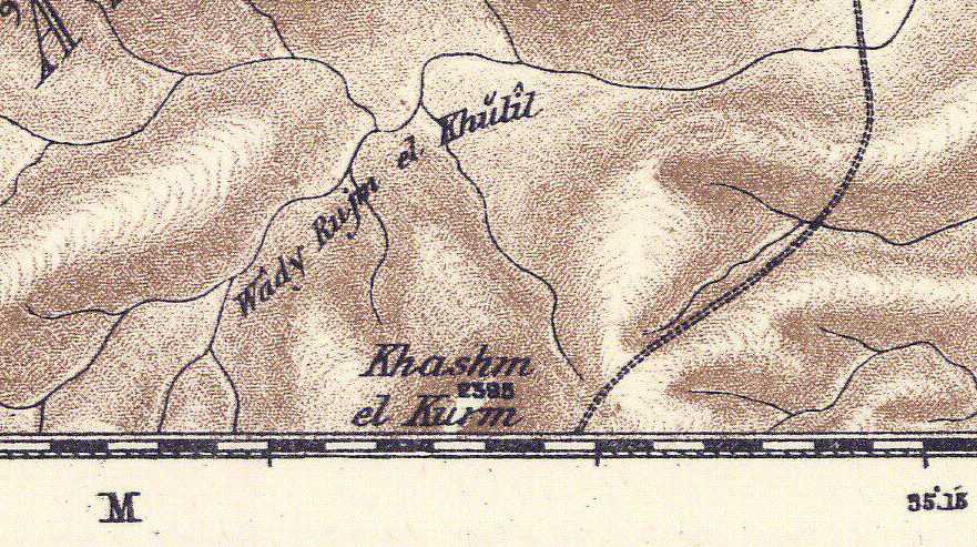
Below, Wady Rujm el Khulil, biblical Havilah (From the Hebrew root: khool?) E of Carmel/Kurmul and Telem/Tell Main (?) where Saul launched his attack from (?) on Amalek? When Israel attempted to invade the Hill Country of Seir she was routed from Seir to Hormah by Amalekites, Cananites, and Amorites (Nu 14:39-45 and De 1:44):. Could Hormah, pronounced in Hebrew Khormah, be Khasm el Kurm S of Khulil and the Amalekites at Wady Malaki (PEF Map sheet 21)?
Below, Wady Malaki may preserve Amalek (?) in the wilderness of Judah E of Carmel/Kurmul attacked by King Saul (PEF Map 1878 Sheet 21). Wady Malaki is N of Wady Rujm el Khulil.
Below, Wadi el Keni may preserve (?) the Kenites who settled in the wilderness
of Judah near the negeb of Arad (Jdgs 1:16)? Saul warned the Kenites to
separate themselves from the Amalekites to avoid being accidentally slain by
Israel (1 Sam 15:6) (Alois Musil. ca. 1907. Karte von Arabia Petraea.
Vienna, Austria. Scale: 1:300,000).
Judges 1:16-18 RSV
And the descendants of the Kenite, Moses' father-in-law, went up from the city
of palms [a palm tree is called tamar] into the wilderness of Judah, which
lies in the Negeb near Arad and they went and settled with the people. And
Judah...defeated the Canaanites who inhabited Zephath and utterly destroyed
it. So the name of the city was called Hormah...Judah took Gaza with its
territory..."
Of interest is that Musil's Iron Age II settlement of Razze (ca. 1907 Karte
von Arabia Petraea) is now rendered as Gazza on more modern maps. Was this
the Gaza that was captured by Judah (Judgs 1:17) rather than Gaza on the
Philistine coast?
Below, Wady Malaki E of Carmel (identified as Sela-Ham-Mahlekoth?) may
preserve Amalek as a toponymn.
Below, Umm es Seir, a possible Arabic toponym for the Hill Country of Seir
(?), SW of Edh Dhariyeh and S of Hebron. Israel was routed in the Hill country
from Seir to Hormah by Amalekites and Canaanites (Nu 14:39-45) whereas it is
Amorites in Deuteronomy (De 1:44) (PEF 1878 Map sheet 21).
The "linch-pins" for identifying Saul's defeat of Amalek from Havilah to Shur
are drawn from several clues:
(1) The Kenites among the Amalekites in the wilderness of Judah near Arad.
(2) The wilderness of Judah being associated with the area between Carmel and
the Dead Sea.
(3) The southern limit of the wilderness of Judah being Arad's Negeb where the
Kenites and Amalekites are.
(4) Wady el Keni SE of Arad possibly preserving the Kenites of Arad's Negeb.
(5) Shur (shuwr) possibly being ez Zuweirah by Wady el Keni, the S terminus of
the Wilderness of Judah?
(6) Havilah as the Hebrew root khool being Wady Rujm el Khulil (PEF
1878 Map sheet 21)
(7) Amalek being Wadi Malaki N of Khulil (Havilah/Khulil is crossed first to
begin the assault on Amalek at Malak
ALTERNATELY
Saul's rout of Amalek "from Havilah to Shur" might be (?) along the Great
Caravan Trade Route from Jerusalem via Hebron, Beersheba, Khalasa, and
Muweilah to Wadi et-Tumilat (Etham?), Lake et-Timsah (Etham?) and Bir Abu
Suwayr (Shur, Hebrew: shuwr).
Havilah on this trade route might be Hebron and/or Wadi el-Khulil. How so?
In Arabic Hebron is called el-Khulil "the friend of God" an epithet alluding
to Abraham as being "God's friend." The below Palestine Exploration Fund Map
of 1878 (scale of 1:63,000) shows Hebron as el-Khulil and the general region
as Khulil (later maps however prefer the spelling Khalil instead of the 1878
Khulil). Maps show that the Great Trade Route between Hebron and Beersheba,
headed for Egypt, parallels Wadi el-Khulil whose headwaters apparently begin
at Hebron/Khulil. In this scenario "Havilah to Shur" would mean that portion
of the Darb es Shur (Arabic: "Way to Shur") from Khulil/Hebron and Wadi el-Khulil
(Havilah?) to Shur (Bir Abu Suwayr)?
If el-Khulil (Hebron) preserves the Hebrew root Chuwl/Khool/Kheel of Havilah
(?) then Saul perhaps (?) chased Amalek from Hebron to Bir Abu Suwayr (Hebrew
Shur/shuwr) on the Great Trade Route from Jerusalem to Bilbeis, Egypt. That is
to say Shuwr/Shur is _not_ a "wall" its the "well" of Bir Abu Suwayr on this
trade route lying on the N side of Wadi
et-Tumilat just W of Lake et-Timsah.
Below, Wadi el-Khulil (1861) draining south from el-Khulil (Hebron) to Beersheba is paralleled on its north side by the Great Caravan Trade Route from Jerusalem to Wadi et-Tumilat, Egypt and Bir Abu Suwayr, my Shur, via Hebron, Beersheba and Muweilah ("Palestine or the Holy Land." The Royal Atlas of Modern Geography. London & Edinburgh. William Blackwood & Sons. 1861). Was Saul's rout of Amalek "from Havilah to Shur" from that portion of the Great Trade Route near Wadi el-Khulil to Shur/Suwayr (the Great Caravan Trade Route being alluded to as "what" Amalek was fleeing upon to get to Egypt)?
Below, a map (1878) showing the Great Caravan Trade Route paralleling Wady el-Khulil (Havilah?) near Beersheba.
Below, Bir Abou Soyair, modern map's (1970s) Abu Suwayr, on the great caravan route from Jerusalem, Hebron, Beersheba, Khalasa, and Muweilah to Belbeis in the Egyptian Delta (C. L. F. Panckoucke. Paris. 1:100,000. 1826. Flle 31 Suez Canal), my proposal for "Shur that is before Egypt."
Below, same map, panorama view, Bir Abou Soyair/Abu Suwayr is on the N side of
Wadi et-Tumilat and NW of Bahr et-Timsah (Lake Timsah). Perhaps Etham is
preserved in Wadi et-Tumilat and Bahr et-Timsah? The wilderness of Shur is an
alternate name for the wilderness of Etham in the Exodus accounts (Ex 15:22;
Nu 33:8). Herodotus was told by Egypt's priests that land watered by the Nile
was Egypt. In antiquity Wadi et-Tumilat received the Nile's waters which
filled Lake et-Timsah. The Bible states that Israel camped at Etham at the
"edge of the wilderness" (Ex 13:20; Nu 33:6) which suggests for me Etham is
part of Egypt and it is Wadi et-Tumilat and Bahr et-Timsah (et-Tum and et-Tim
possibly preserving Etham?). Once Etham is left, Egypt is left, and Israel is
now in the wilderness of Etham/Shur headed for
Marah whose waters were bitter, possibly (?) the two Bitter Lakes S of
Etham/Et-Timsah called in Arabic Buheirat el Murrat or "bitter." Thence to
Elim's 12 springs, the 12 artesian springs of Ayun Musa, "the springs of
Moses," and its 70 palm trees E of the port of Suez.
Below, Bir Abou Soyair (1826) is rendered (1970s) Abu Suwayr and is the site of a military air base (white circle). For me the Hebrew rendering of Shur as Shuwr (Strong 7793 Hebrew & Chaldee Dictionary) resembles somewhat Suwayr.
Below, the Bible's "Way to Shur," (Ge 16:7) Arabic: Darb es Shur, the
Great Caravan Route from Jerusalem via Hebron, Beersheba, Khalasa and Muweilah
to Egypt, passing the N side of Bahr et-Timsah (Lake et-Timsah) and
intersecting with Bir Abu Suwayr/Bir Abou Soyair (my Shur that is before
Egypt) to the N of Wady et-Tumilat. If Havilah is el Khulil (Hebron) then Saul
chased the Amalekites from Khulil (Hebrew: Chuwl/Khool being the root of
Havilah/Khavilah) all the way to Egypt (which in my opinion is highly
unlikely, this is probably just gross exaggeration or hyperbole).
Special Note:
It appears to me that the Hebrews at times misunderstood, misspelled, and
mispronounced foreign words, perhaps they "heard" the foreign pronunciation
incorrectly?
For example the city of Erech (Ge 10:10) in Mesopotamia in Akkadian
(Babylonian) is Uruk. Ararat (Ge 8:4) in Assyrian was Urartu. Sumerian edin
(meaning "a back," the uncultivated land "backing" or surrounding the gods'
city-gardens in Sumer) became Genesis 'eden ("pleasure" or "delight" Ge 2:8)
apparently via homophone/homonym confusion. Hazarmaveth, "village of death" (Ge
10:26), is actually wady Hadhramaut in the Yemen.
English rendered Havilah (Ge 10:28), Hebrew Khaveelah,
_if_ derived from khool or kheel, apparently mispronounces the
Yemeni/Saudi Khaulan, or khool leaving off the "-on"
sufformative. If for over 100 years (1875) scholars have correctly associated
Havilah with the Khaulan in SW Arabia, then a similar Arabic word form ought
to be sought in Judah as el-Khulil.
If wadies Baish and Bishah are Genesis' Pishon (Pison) then again, the Hebrew
ear apparently heard b as p, and added an "-on" sufformative.
|
|
Tweet
Copyright © 2008
- 2024
Discovering Islam All rights reserved www.DiscoveringIslam.org
Last modified:
Thursday January 04, 2024 02:06 PM
Privacy |